Hurricane Helene strengthens as it bears down on Florida
Hurricane Helene continues to strengthen as it barrels toward the US Gulf Coast.
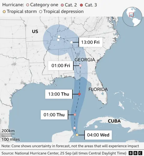
The Category 1 storm is on track to quickly intensify into a dangerous Category 4 hurricane by the time it makes landfall in Florida on Thursday evening, with forecasters warning it could bring “life-threatening” storm surge, damaging winds and flooding to a large part of Florida and the south-eastern US.
The US-based National Hurricane Center (NHC) said that Helene was expected to continue moving north through the Gulf of Mexico before striking Florida on Thursday evening local time.
The governors of Florida, Georgia, North Carolina, South Carolina and Virginia have declared states of emergency ahead of the storm’s landfall.
Map of Hurricane Helene’s path

Data from the (NHC) indicates that maximum sustained winds from the storm have increased to 85 mph (140 km/h).
By Thursday night, Helene was moving north at 12mph (19km/h) through the Gulf of Mexico, the NHC said in an update.
The NHC warned that that Helene is turning into a “major” storm that could reach Category 4 status by the time it reaches Florida.
At a news conference on Thursday, the mayor of Tallahassee, Florida, warned residents to be prepared.
“We have no more time left to wait. Today is the day. We urge you to stay weather aware as we’re on the verge of what could be … a historic event,” Mayor John Dailey said.
In Georgia, all public schools in Atlanta will close on Thursday and Friday due to the storm. It has also affected the race for the White House, with Republican candidate for vice-president JD Vance cancelling two events in Georgia that were planned for Thursday.
All across the southeastern US, the storm could trigger “catastrophic and potentially life-threatening flash and urban flooding,” the NHC said.
Before reaching the US, the storm is expected to dump 4-8 inches (10-20cm) of rain on parts of Cuba and the Cayman Islands.
In Mexico, the popular resorts of Cancún and Cozumel were lashed with heavy rainstorms and wind in the early hours of Wednesday local time.
Flooding was reported in some areas.
Red flags warning swimmers not to venture into the sea were flying on the beaches of Cancún as early as Tuesday and fishermen rushed to get their small boats out of the water.
Local businesses were boarding up their windows as torrential rain began to fall and high winds blew.
The NHC said that once Helene reaches the south-eastern United States, it is expected to “produce total rain accumulations of five to 10 inches” (12.7-25.4cm).
A flood watch has been issued from Florida to the southern Appalachians with the worst-affected area predicted to be the Big Bend region in Florida.
Big Bend is where Hurricane Idalia made landfall in 2023 and the area also was impacted by Hurricane Debby last month.
The Florida Division of Emergency Management has posted a list of the counties in which voluntary or mandatory evacuation orders have been issued ahead of Helene.

